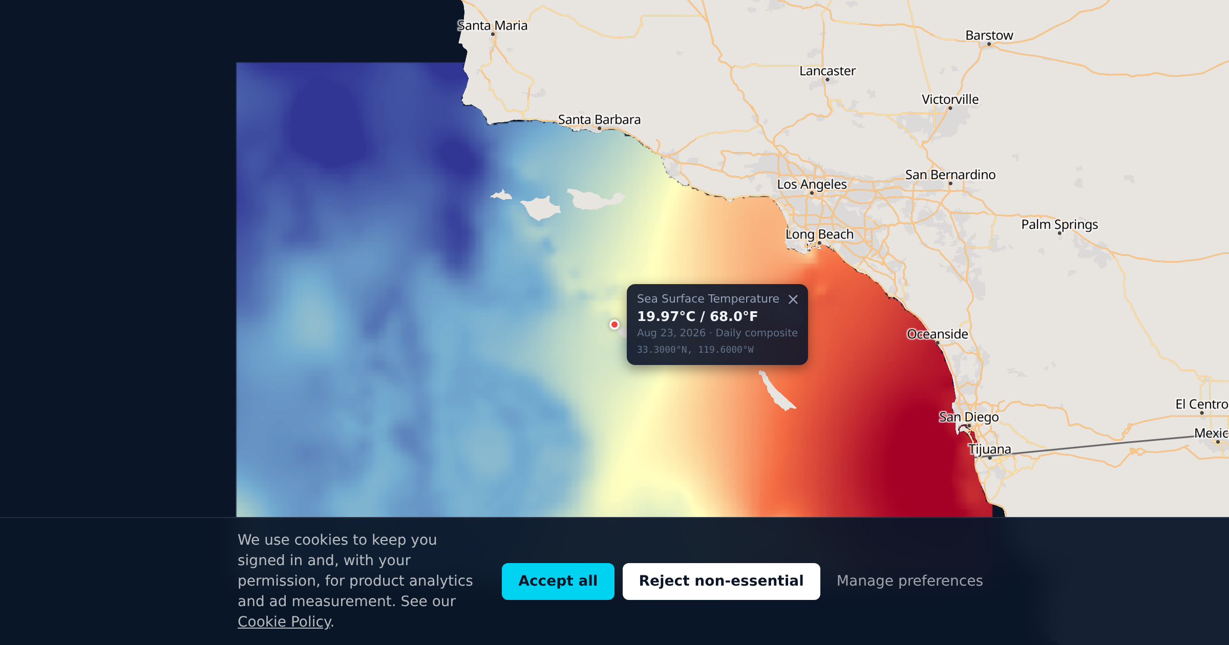
Southern California's waters are some of the most productive and data-dependent in the Pacific. From Point Conception to the Mexican border, the SoCal Bight is shaped by the California Current, seasonal upwelling, and underwater structure that creates world-class fishing from the kelp beds to the offshore banks, plus some of the best cold-water spearfishing and diving on the West Coast.
Whether you're running offshore for bluefin, dropping on calicos in the kelp, or freediving a reef for white seabass, the same data tells you where to go. Temperature drives the fish. Chlorophyll tells you where the food chain is alive. And visibility determines whether you can see anything once you get in the water.
Why Water Temperature Runs These Waters
Everything in SoCal comes down to water temperature and what it's doing at the edges.
Offshore, temperature breaks are everything. Where cool upwelled water meets warmer offshore water, bait concentrates along the edge. Kelp paddies drift into these seams. And gamefish stack up to feed. Even a one or two degree shift over a short distance changes everything. A boat fishing the wrong side of a break can go blank while boats a mile away are on wide-open yellowfin.
Inshore, temperature drives seasonal patterns just as hard. Calico bass activity picks up when water warms into the low 60s. White seabass follow squid spawns that track specific temperature bands. Halibut move shallow or deep depending on seasonal water temps and where the bait is sitting.
For divers and spearfishermen, temperature determines what species are on the reef, how active they are, and whether you need a 7mm suit or can get away with a 5. It also drives the thermocline depth, which affects where fish hold in the water column. A spearfisherman hunting yellowtail on a kelp paddy cares about the same SST break that a troller is running to. The data is the same. The approach is different.
Species and Seasons
Calico bass (kelp bass): The most targeted species for SoCal private boaters and one of the best spearfishing targets in the kelp. Year-round residents of the kelp beds, rocky reefs, and structure from the coast out to the islands. Most active when water temps climb into the low-to-mid 60s. Trophy fish live in deeper structure and boiler rocks. The islands (Catalina, San Clemente, the Channel Islands) hold the biggest fish. Calicos also show up around offshore kelp paddies in warmer months. Spearfishermen target them in the kelp canopy and around rocky points where they ambush bait.
White seabass: The trophy inshore species for both hook-and-line and spearfishing. Spawning runs follow squid, which track specific water temperature windows, typically 58-65°F. When squid are spawning on the flats, white seabass are right there. Best March through June, with a secondary fall window. Kelp edges and sandy flats near structure are prime territory. For spearfishermen, white seabass in the kelp during a squid spawn is the pinnacle of SoCal diving. Visibility matters enormously for this hunt.
California halibut: Year-round fishery along sandy bottoms near kelp beds, bays, and coastal structure. They move shallower in spring and summer as water warms. Found from the surf zone out to about 100 feet. Most consistent March through September. Spearfishermen take halibut on sand flats adjacent to kelp, usually spotting them camouflaged on the bottom. Clear water makes or breaks this hunt.
Yellowtail: June through October when inshore water hits 60°F. Found around kelp paddies, rocky structure, and named banks like 9 Mile Bank. A resident "home guard" holds year-round near the Coronado Islands, San Clemente, and Catalina. One of the most prized spearfishing targets in SoCal. Freediving kelp paddies for yellowtail has become one of the fastest-growing segments of SoCal spearfishing.
Bluefin tuna: Can appear as early as March in warm years, typically May or June through November. Prefer water in the mid-60s°F. Trophy fish range from 40 to 300+ lbs. Found on offshore banks like 60 Mile Bank, the 302, 425, and points south into Mexico. Recent years have seen banner seasons with fish surprisingly close to shore.
Yellowfin tuna: Summer and fall, prefer warmer water in the 70-80°F range. Often found under kelp paddies or on temperature breaks. Usually arrive later than bluefin.
Dorado (mahi-mahi): Late summer into fall, warm water species. Found under kelp paddies, sometimes as close as 5 miles off the beach. Follow the warm water. When paddies are holding dorado, they're usually holding yellowtail and sometimes tuna underneath too.
Sheephead, lobster, and reef species: For divers, the kelp forests and rocky reefs hold California sheephead, various rockfish species, and spiny lobster (season: October through March). Water temperature and visibility determine how productive a dive will be. Warmer water in late summer brings better vis but also more boat traffic. Winter diving can be surprisingly clear after storms push through.
Striped marlin, wahoo, albacore: Summer and fall offshore species that follow temperature breaks. Marlin and wahoo in warm years. Albacore traditionally arrive around the Fourth of July when water hits the mid-60s.
The Spots You're Looking For
Inshore, SoCal's kelp beds run nearly the entire coastline from Santa Barbara to the border. La Jolla, Point Loma, Dana Point, Catalina's frontside, San Clemente Island's east side. These kelp lines are where calicos live, white seabass hunt squid, halibut work the sandy patches between the stringers, and spearfishermen spend most of their time. Chlorophyll data shows you where these nearshore beds are most productive. For scuba divers, the same kelp forests are the destination. Visibility is the variable that makes or breaks a dive day.
Offshore, anglers run to named high spots on underwater banks that create current deflections and nutrient upwelling. The 209, 181, 302, 425, 390, Hidden Bank, San Salvador Knoll, Tanner Bank, Cortez Bank. These numbers (depths in fathoms) are burned into the brain of every serious offshore angler from San Diego to Santa Barbara. Cortez Bank also attracts big-wave surfers and adventurous freedivers when conditions align.
But the fish don't always stay on the structure. They follow the water. A warm eddy that parked over the 302 last week might have drifted 20 miles by Saturday. That's why satellite data matters more than a waypoint.
Kelp paddies are the other game, and they matter to both anglers and spearfishermen. Floating mats of kelp that attract baitfish, yellowtail and dorado near the surface, with tuna often holding deep underneath. Paddies tend to concentrate along temperature breaks and current edges. If you can see the breaks on satellite data, you can narrow down where to look.
What Chlorophyll Tells You That Temperature Can't
Most SoCal anglers know SST charts. Fewer use chlorophyll data, and that's a missed opportunity. For divers and spearfishermen, it might be the more important dataset.
Chlorophyll-a concentration shows you where phytoplankton are blooming. Phytoplankton bloom where nutrients are being upwelled to the surface. That's the start of the food chain. Baitfish eat the plankton. Gamefish eat the baitfish. A temperature break with high chlorophyll on one side means the whole food chain is active there. A temperature break with dead-clear water on both sides might hold nothing.
Inshore, chlorophyll helps you read the kelp beds. Areas with higher productivity around kelp edges tend to hold more bait, which means more calicos, more white seabass following the food, and more halibut underneath.
For spearfishermen and divers, chlorophyll is a direct read on visibility. High chlorophyll means green water and reduced vis. Low chlorophyll means blue water. If you're planning a freedive on a reef or a kelp bed, this is the difference between a 30-foot vis day and a 10-foot vis day. Chlorofishy converts chlorophyll concentration into estimated Secchi depth so you can check visibility conditions before you drive to the harbor.
June Gloom and Why Raw Passes Matter
If you've been on the water in SoCal in May or June, you know the marine layer. Weeks of overcast skies. And here's the problem: traditional SST satellites can't see through clouds. So during the exact weeks when offshore season is ramping up and you need data most, cloud-free composites are filling in gaps with old data and model estimates.
That's not necessarily wrong. But it's not what the ocean looked like this morning.
Chlorofishy shows you both. Composites give you the smoothed big-picture view. Raw satellite passes show you exactly what each satellite saw on its last overpass, clouds and all. You can see where the data is real and where it's a gap. No guessing about which pixels are measured and which are modeled.
SoCal Ocean Science in Plain English
The California Current flows south along the entire West Coast, carrying cold, nutrient-rich water from the north Pacific. When northwesterly winds blow along the coast (strongest in spring and summer), they push surface water offshore. Cold water from the deep rises to replace it. That's upwelling, and it's the engine that powers the entire SoCal food chain.
The Southern California Bight is a bit different from central and northern California. The coastline curves inland, the Channel Islands create complex current patterns, and upwelling is weaker and more localized. But small eddies around the islands (most under 50km across) create their own little upwelling zones that fuel localized productivity. These show up on chlorophyll imagery as green patches near island structure.
El Nino years weaken upwelling and bring warmer water north. That pushes tropical species like dorado and yellowfin closer to shore and can bring exotic visitors like wahoo and blue marlin into SoCal waters. Diving visibility tends to improve in El Nino years as chlorophyll production drops. La Nina years strengthen upwelling, cool the water, and favor productivity but can mean greener, murkier conditions nearshore. Understanding which phase you're in helps set expectations for the season, whether you're holding a rod or a speargun.
Fishing & Diving Calendar
March-May: Early season. Bluefin can show in warm years on offshore banks. White seabass start chasing squid spawns in the kelp, and this is prime time for spearfishing them. Calico bass fishing picks up as water warms. Halibut move shallow. Lobster season closes in March. Water 58-63°F.
June-July: Season ramps hard. Bluefin and yellowfin move into range. Yellowtail arrive inshore. Kelp paddies start holding dorado. Albacore push in around July. Calico and white seabass fishing peaks. Dive vis can be hit or miss during June gloom. Water 63-68°F.
August-October: Peak season across the board. Everything is in play offshore. Best paddy fishing and paddy spearfishing. Inshore calico bite stays strong. Dive visibility often peaks in late summer and early fall as water clears. Lobster season opens in October. Water 68-74°F.
November-December: Offshore season winds down as water cools. Calicos, halibut, and rockfish keep the inshore game alive. Lobster season in full swing for divers. Home guard yellowtail hold near the islands. Water clarity can be excellent between storms.
January-February: Traditionally quiet offshore. Calico bass, rockfish, sheephead, and halibut keep inshore anglers and divers busy year-round. Lobster season continues through March. Winter storms can bring surges of clear water between swells.
Fishing nearby waters too? Central California and Baja North are the closest covered regions. See pricing for what a plan covering Southern California costs.